Sunday, May 18, 2014

GREAT PYRAMID OF GIZA


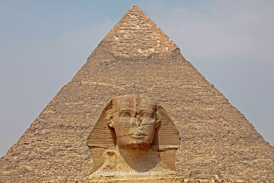
The most amazing pyramid- Pyramid of Giza


Wonderful sunset !!


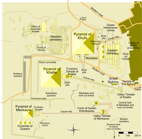
The map  of Pyramid Giza

Location : Great Pyramid Of Giza, Giza, Egypt.

 The Great Pyramid of Giza (also known as the Pyramid of Khufu or the Pyramid of Cheops) is the oldest and largest of the three pyramids in the Giza Necropolis bordering what is now El Giza, Egypt. It is the oldest of the Seven Wonders of the Ancient World, and the only one to remain largely intact. Based on a mark in an interior chamber naming the work gang and a reference to fourth dynasty Egyptian Pharaoh Khufu, Egyptologists believe that the pyramid was built as a tomb over a 10 to 20-year period concluding around 2560 BC. Initially at 146.5 metres, the Great Pyramid was the tallest man-made structure in the world for over 3,800 years. Originally, the Great Pyramid was covered by casing stones that formed a smooth outer surface, what is seen today is the underlying core structure. Some of the casing stones that once covered the structure can still be seen around the base. There have been varying scientific and alternative theories about the Great Pyramid's construction techniques. Most accepted construction hypotheses are based on the idea that it was built by moving huge stones from a quarry and dragging and lifting them into place.

File:KhufuPyramidCasingStone-BritishMuseum-August19-08.jpg 

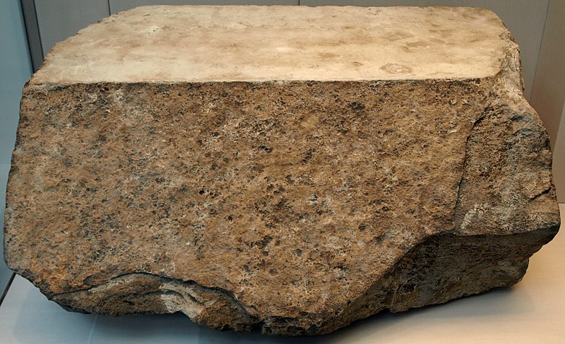
Casing stone for the Great Pyramid

File:PyramidDatePalms.jpg
                    
                                                   Great Pyramid of Giza in 19th century

The Great Pyramid consists of an estimated 2.3 million limestone blocks which most believe to have been transported from nearby quarries. The Tura limestone used for the casing was quarried across the river. The largest granite stones in the pyramid, found in the "King's" chamber, weigh 25 to 80 tonnes and were transported from Aswan, more than 800 km away. Traditionally, ancient Egyptians cut stone blocks by hammering wooden wedges into the stone which were then soaked with water. As the water was absorbed, the wedges expanded, causing the rock to crack. Once they were cut, they were carried by boat either up or down the Nile River to the pyramid. It is estimated that 5.5 million tonnes of limestone, 8,000 tonnes of granite (imported from Aswan), and 500,000 tonnes of mortar were used in the construction of the Great Pyramid.

File:Great Pyramid Diagram.svg

Diagram of the interior structure of the Great Pyramid of Giza

The original entrance to the Great Pyramid is 17 metres vertically above ground level and 7.29 metres east of the center line of the pyramid. After 105.23 metres, the passage becomes level and continues for an additional 8.84 metres to the lower Chamber, which appears not to have been finished. There is a continuation of the horizontal passage in the south wall of the lower chamber, there is also a pit dug in the floor of the chamber. At the start of the Grand Gallery on the right-hand side there is a hole cut in the wall, (and now blocked by chicken wire). This is the start of a vertical shaft which follows an irregular path through the masonry of the pyramid to join the Descending Passage. Also at the start of the Grand Gallery there is a Horizontal Passage leading to the "Queen's Chamber". The passage is 1.1 metre high for most of its length, but near the chamber there is a step in the floor, after which the passage is 1.73 metres high.

ANGEL FALLS

  Most incredible waterfall !!

Beautiful waterfall  

  Map of Angle Falls

Location : Auyantepui, Canaima National Park, Bolivar State, Venezuela.

Angel Falls is the world's highest uninterrupted waterfall, with a height of 979 metres and a plunge of 807 metres. The waterfall drops over the edge of the Auyantepui mountain in the Canaima National Park, a UNESCO World Heritage site in the Gran Sabana region of Bolívar State. The height figure 979 metres mostly consists of the main plunge but also includes about 400 metres of sloped cascades and rapids below the drop and a 30 metres high plunge downstream of the talus rapids.

Angel Falls, Venezuela

Image from the top of waterfall

Angel Falls is one of Venezuela's top tourist attractions, though a trip to the falls is a complicated affair. The falls are located in an isolated jungle. A flight from Puerto Ordaz or Ciudad Bolívar is required to reach Canaima camp, the starting point for river trips to the base of the falls. River trips generally take place from June to December, when the rivers are deep enough for the wooden curiaras used by the Pemon guides. During the dry season (December to March) there is less water seen than in the other months.


Angel Falls also inspired the setting of the Disney animated film Up (2009) although, in the film, the location was called Paradise Falls instead of Angel Falls. It also makes a small appearance in the Disney film Dinosaur, as well as the 1990 film Arachnophobia.


THE WAVE


Incredible place - The Wave


The Wave


Map of The Wave

Location : Coconino County, Arizona, U.S.A.

The Wave is a sandstone rock formation located in the United States of America near the Arizona-Utah border, on the slopes of the Coyote Buttes, in the Paria Canyon-Vermilion Cliffs Wilderness, on the Colorado Plateau. It is famous among hikers and photographers for its colorful, undulating forms, and the rugged, trackless hike required to reach it. Consists of intersecting U-shaped troughs that have been eroded into Navajo Sandstone of Jurassic age. The two major troughs, which comprise this rock formation, are 62 feet wide by 118 feet long and 7 feet wide by 52 feet long.

 The Wave exposes large-scale, sets of cross-bedded eolian sandstone composed of rhythmic and cyclic alternating grain flow and wind ripple laminae. The rhythmic and cyclic alternating laminae represent periodic changes in the prevailing winds during the Jurassic as huge sand dunes migrated across a sandy desert. The thin ridges and ribbing seen within The Wave are the result of the differential erosion of rhythmic and cyclic alternating grain flow and wind ripple laminae within the Navajo Sandstone. These laminae have differing resistance to erosion as they have been differentially cemented according to variations in the grain size of the sand composing them. The soft sandstone, including the ridges and ribbing, of The Wave is fragile. As a result, persons must walk carefully to avoid breaking the small ridges.

Tourists can go to The Wave by the any vehicles at the good weather. During and after a storm the road may be impassable, even with a four-wheel-drive vehicle. Wire Pass Trailhead includes a wide parking lot with restrooms, but no water. It is also accessible from the Arizona side by taking U.S. Highway 89A from Jacob Lake on the Kaibab Plateau toward Navajo Bridge, turning north onto the House Rock Valley Road, after descending from the Kaibab. This is a longer access route over dirt road than from the Utah side. From the Wire Pass Trailhead, The Wave can be reached by hiking approximately 4.8 km across open desert, making the round-trip to and from The Wave nearly 9.7 km climbing about 110 metres in altitude.

PLITVICE LAKE

 Incredible view from the top  

  Beautiful Lake

Map of Plitvice Lake 

Location : Plitvice Lakes National Park, Croatia.

Plitvice Lakes National Park is the oldest national park in Southeast Europe and the largest national park in Croatia. The national park was founded in 1949 and is situated in the mountainous karst area of central Croatia, at the border to Bosnia and Herzegovina. The important north-south road connection, which passes through the national park area, connects the Croatian inland with the Adriatic coastal region. In 1979, Plitvice Lakes National Park was added to the UNESCO World Heritage register among the first natural sites worldwide. Each year, more than 1,200,000 visitors are recorded.

The national park is world famous for its lakes arranged in cascades. Currently, 16 lakes can be seen from the surface.  These lakes are a result of the confluence of several small rivers and subterranean karst rivers. The lakes are all interconnected and follow the water flow. The sixteen lakes are separated into an upper and lower cluster formed by runoff from the mountains, descending from an altitude of 636 to 503 meter over a distance of some eight km, aligned in a south-north direction. The lakes collectively cover an area of about two square kilometres, with the water exiting from the lowest lake forming the Korana River.

File:Cypripedium calceolus wiki mg-k01.jpg File:Brown Bear us fish 2.jpg
                       The lady's-slipper orchid                                                 Brown bear

The Plitvice Lakes national park is heavily forested, mainly with beech, spruce, and fir trees, and features a mixture of Alpine and Mediterranean vegetation. Scientists have so far listed 1,267 different plants out of 109 species that can be found within the area of the national park. The area of the national park also is home to an extremely wide variety of animal and bird species. Rare fauna such as the European brown bear, wolf, eagle, owl, lynx, wild cat and capercaillie can be found there, along with many more common species. As regards bird species, the Plitvice Lakes rank third among other Croatian national parks. Up to now, 157 species have been counted, of which 70 have been recorded as breeding there. 


MALDIVES


Maldives from the top


Maldives beautiful beach


Night in Maldives


Map of Maldives

Location : Male, Republic of the Maldives.

Maldives, officially the Republic of the Maldives and also referred to as the Maldive Islands, is an island nation in the Indian Ocean-Arabian Sea area, consisting of a double chain of twenty-six atolls, oriented north-south, that lie between Minicoy Island (the southernmost part of Lakshadweep, India) and the Chagos Archipelago. The chains stand in the Laccadive Sea, about 700 kilometres south-west of Sri Lanka and 400 kilometres south-west of India. The Maldives is the smallest Asian country in both population and land area. With an average ground level elevation of 1.5 metres above sea level, it is the planet's lowest country. It is also the country with the lowest natural highest point in the world, at 2.4 metres. Forecasts predicting future inundation of the Maldives due to rising sea levels are of great concern to its people.

File:Friday mosque minaret Male1981.jpg

Oldest Mosque in Maldives (Hukuru miskiy)

Most of the Maldives communities are Muslim. The famous Moroccan traveller Ibn Batutta, who visited the Maldives in the 14th century, wrote how a Moroccan, one Abu Barakat the Berber, was believed to have been responsible for spreading Islam in the islands. Even though this report has been contested in later sources, it does explain some crucial aspects of Maldivian culture. For instance, historically Arabic has been the prime language of administration there, instead of the Persian and Urdu languages used in the nearby Muslim states. Another link to North Africa was the Maliki school of jurisprudence, used throughout most of North-Africa, which was the official one in the Maldives until the 17th century.

File:Maldives Oriental sweetlips, Plectorhinchus vittatus.jpg File:Hibiscus tilliaceus or Sea Hibiscus.jpg
                   Oriental Sweetlips                                              Sea Hibiscus                                   
Maldives consists of 1,192 coral islands grouped in a double chain of 26 atolls, along the north-south direction, spread over roughly 90,000 square kilometres, making this one of the world's most dispersed countries. Maldives waters are home to several ecosystems, but are most noted for their variety of colourful coral reefs, home to 1100 species of fish, 5 species of sea turtles, 21 species of whales and dolphins, 187 species of corals, 400 species of molluscs, and 83 species of echinoderms. Many crustacean species are there as well 120 copepod, 15 amphipod as well as over 145 crab and 48 shrimp species.

Resort in Maldives
The Maldives remained largely unknown to tourists until the early 1970s. Only 185 islands are home to its 300,000 inhabitants. The other islands are used entirely for economic purposes, of which tourism and agriculture are the most dominant. Tourism accounts for 28% of the GDP and more than 60% of the Maldives' foreign exchange receipts. Over 90% of government tax revenue comes from import duties and tourism-related taxes. The development of tourism fostered the overall growth of the country's economy. It created direct and indirect employment and income generation opportunities in other related industries. The first tourist resorts were opened in 1972 with Bandos island resort and Kurumba Village, which transformed the Maldives economy. The number of resorts increased from 2 to 92 between 1972 and 2007. As of 2007, over 8,380,000 tourists had visited Maldives. Tourism was also the country's biggest foreign currency earner and the single largest contributor to the GDP.


HA LONG BAY

  View of Ha Long Bay

 Ha Long Bay Cruise 

 Ha Long Bay map

Location : Ha Long Bay, Vietnam.

Hạ Long Bay (Vietnamese: Vịnh Hạ Long, literally: "descending dragon bay") is a UNESCO World Heritage Site, and a popular travel destination, in Quảng Ninh Province, Vietnam. Administratively, the bay belongs to Hạ Long City, Cẩm Phả town, and part of Vân Đồn District. The bay features thousands of limestone karsts and isles in various sizes and shapes. Hạ Long Bay is a center of a larger zone which includes Bái Tử Long bay to the northeast, and Cát Bà islands to the southwest. These larger zones share similar geological, geographical, geomorphological, climate, and cultural characters.

File:Thien Cung.jpg

Thien Cung grotto in Ha Long Bay, Vietnam

The bay consists of a dense cluster of some 1,600 limestone monolithic islands each topped with thick jungle vegetation, rising spectacularly from the ocean. Several of the islands are hollow, with enormous caves. Hang Đầu Gỗ (Wooden stakes cave) is the largest grotto in the Hạ Long area. French tourists visited in the late 19th century, and named the cave Grotte des Merveilles. Its three large chambers contain large numerous stalactites and stalagmites (as well as 19th century French graffiti). There are two bigger islands, Tuần Châu and Cát Bà, that have permanent inhabitants, as well as tourist facilities including hotels and beaches. There are a number of beautiful beaches on the smaller islands. The community in Ha Long Bay live on floating houses and are sustained through fishing and marine aquaculture (cultivating marine biota), plying the shallow waters for 200 species of fish and 450 different kinds of mollusks. Many of the islands have acquired their names as a result of interpretation of their unusual shapes. Such names include Voi Islet (elephant), Ga Choi Islet (fighting cock), Khi Islet (monkey), and Mai Nha Islet (roof). 989 of the islands have been given names. Birds and animals including bantams, antelopes, monkeys, and lizard also live on some of the islands.

In 2000, the UNESCO’s World Heritage Committee has inscribed the Hạ Long Bay in the World Heritage List according to its outstanding examples representing major stages of the Earth’s history and its original limestone karstic geomorphologic features. The hundreds of rocky islands with form the beautiful and famous landscape of the Bay are the individual towers of a classic Fenglin landscape where the intervening plains have been submerged by the sea. Most towers reach a height of between 50 and 100m with a height to width ratio of about 6. The karst dolines were flooded by the sea becoming the abundance of lakes that lie within the limestone islands. For example, Dau Be island at the mouth of the Bay has six enclosed lakes including those of the Ba Ham lakes lying within its fencong karst. The Bay contains examples of the landscape elements of fengcong, fenglin and karst plain. 

Halong Bay is host to two ecosystems: a tropical, moist, evergreen rainforest ecosystem and a marine and coastal ecosystem.  


SOCOTRA


Image of Socotra


Unique three in Socotra


Map of Socotra

Location : Indian Ocean, Yemen.

The largest island, also called Socotra, is about 95% of the landmass of the archipelago. It lies some 240 kilometres east of the Horn of Africa and 380 kilometres south of the Arabian Peninsula. The island is very isolated and a third of its plant life is found nowhere else on the planet. It has been described as "the most alien-looking place on Earth". The island measures 132 kilometres in length and 49.7 kilometres in width.

Socotra is one of the most-isolated landforms on Earth of continental origin. The archipelago was once part of the supercontinent of Gondwana and detached during the Miocene epoch, in the same set of rifting events that opened the Gulf of Aden to its northwest. The main island has three geographical terrains: the narrow coastal plains, a limestone plateau permeated with karstic caves, and the Higher Mountains. The mountains rise to 1,503 metres.

File:Cucumber Tree (Dendrosicyos).jpg      File:Socotra Cave 02.JPG
      Cucumber three in Socotra                                                       Halah Cave


Socotra also have the unique of flora and fauna. Socotra is considered the jewel of biodiversity in the Arabian Sea. In the 1990s, a team of United Nations biologists conducted a survey of the archipelago’s flora and fauna. They counted nearly 700 endemic species, found nowhere else on earth. One of the most striking of Socotra's plants is the dragon's blood tree (Dracaena cinnabari), which is a strange-looking, umbrella-shaped tree. Its red sap was thought to be the dragon's blood of the ancients, sought after as a dye, and today used as paint and varnish. Also important in ancient times were Socotra's various endemic aloes, used medicinally, and for cosmetics. Other endemic plants include the giant succulent tree Dorstenia gigas, the cucumber tree Dendrosicyos socotranus, the rare Socotran pomegranate (Punica protopunica), Aloe perryi, and Boswellia socotrana. The island group also has a rich fauna, including several endemic species of birds, such as the Socotra Starling, Socotra Sunbird, Socotra Bunting, Socotra Cisticola, Socotra Sparrow, Socotra Golden-winged Grosbeak, and a species in a monotypic genus, Socotra Warbler.